

Hi, Team!
Does anybody recognize what this is? Could you point out where you think you live on this map?
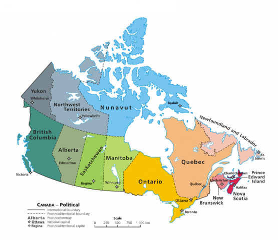
We live in British Columbia, down in the far left bottom corner.
British Columbia is the province we live in. Our province is that whole teal area – it’s very big!
Canada has 10 provinces, and 3 territories.
British Columbia, Alberta, Saskatchewan, Manitoba, Ontario, Quebec, New Brunswick, Nova Scotia, Prince Edward Island, and Newfoundland and Labrador are all provinces.
The Yukon, Northwest Territories, and Nunavut are all territories.
The difference between a “province” and a “territory” has to do with who gets to make political decisions for the whole area. Provinces get to make some of their biggest decisions on their own, while territories don’t have that same power, and instead need authority and responsibilities coming from the federal government (that’s the government that helps make decisions for all of Canada, the whole country).
Here is a colouring worksheet you can do while looking at a map of Canada, to show where the different provinces and territories are. It’s a worksheet for older students, so if some of the instructions on it don’t make sense to you, don’t worry about them.
Now, our maps of Canada, with the borders of provinces and territories, are based on boundaries that were decided a long time ago. But we know that Indigenous people lived here long before anyone decided on these boundaries. In order to make some of the decisions that happen within a province or territory, governments needed to make agreements with the Indigenous people who already lived there: this is called a Treaty. A Treaty is an agreement about who is allowed to do what, and who is in charge of taking care of what. Here is a map of Treaties in Canada that you can colour in:
What do you notice about the boundaries in this map of Treaties? What do you notice that is the same as the map of Canada? What do you notice is different?
REVIEW
The country we live in is? (Canada)
The province we live in is? (British Columbia)
Do you know what city we live in? (Burnaby)
Do you know what street you live on? Try an find it on Google Maps. What about what street our school is on?
Try and make a map of your house! How do you get around from room to room? What is in the different rooms? Who spends time in these rooms? What streets are nearby?